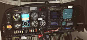
Equipment: GNS530W/430W, Aspen E5, Foreflight, KAP140.
The usual caveat popped up on another thread about the "dangers" of flying the glideslope provided by various GPS navigators when the actual available RNAV approach is not LPV. In my case I get such a glideslope on every LP or LNAV I've encountered. In theory, this GS could cause one to bust a minimum on the way down. In practice I've yet to see this happen. But here is how I go about it.
First, brief the applicable MDA/DA from the FF plate.
With the 530W coupled to the GS, I monitor several bits of information:
1. Foreflight displays, on the map (with or without the plate), each stepdown waypoint altitude and min altitude for each leg.
2. The GNS does not display the leg/stepdown altitude, but does show the leg you are on and a countdown to the next waypoint.
3. Monitor the altitude along the leg and anticipate whether you will descend below the stepdown point before arrival. I monitor 3 altitudes: 2 pressure altimeters + GSL on the 430W screen.
4. If necessary to avoid busting the altitude ( haven't seen it yet), AP is put in ALT hold mode, abandoning the GS and use VS to control descent.
#4 needs some explanation and exercise of judgement. If solid VMC and there is no realistic hazard outside, one could elect to simply continue down. Another factor; Both of my pressure altimeters are within specification (per my last required inspection) and they disagree by as much as 50 ft. The GSL will almost always differ from both. In close to the airport this disagreement is pretty small, so there is some judgement as to which to believe. This complication exists even in the absence of the pseudo-glideslope.
Flying the "unofficial" Garmin glideslope coupled with AP
Moderators: Rick, Lance Murray
-
Rich
- 5 Diamonds Member

- Posts: 4604
- Joined: Mon Aug 30, 2010 12:40 pm
- First Name: Rich
- Aircraft Type: DA40
- Aircraft Registration: N40XE
- Airports: S39 Prineville OR
- Has thanked: 145 times
- Been thanked: 1185 times
Flying the "unofficial" Garmin glideslope coupled with AP
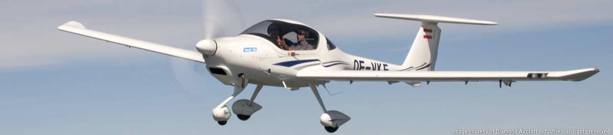
2002 DA40-180: MT, PowerFlow, 530W/430W, KAP140, ext. baggage, 1090 ES out, 2646 MTOW, 40gal., Surefly, Flightstream 210, Orion 600 LED, XeVision, Aspen E5
-
Ed McDonald

- 3 Diamonds Member

- Posts: 116
- Joined: Wed Jun 09, 2021 1:08 am
- First Name: Ed
- Aircraft Type: DA62NG
- Aircraft Registration: CFPWP
- Airports: CFB6
- Has thanked: 9 times
- Been thanked: 125 times
Re: Flying the "unofficial" Garmin glideslope coupled with AP
I am relatively new to the DAN as my DA62 is soon to be delivered however I can offer lots of expertise on this issue and instrument flight procedures as I am a qualified instrument procedure designer and own an engineering firm that does this (www.jetpro.ca). The DA62 is our new flight checking aircraft.
The Garmin LNAV+V or LP+V is a BIG issue for me that I have brought to the attention of the regulator in Canada (Transport Canada). In a nutshell, despite all of the warnings and caveats that Garmin provides in their manuals, etc., the vertical path created by the GPS navigator is providing hazardous and misleading information.
Vertically guided approaches (ILS, LPV, LNAV/VNAV) all have the area near the approach threshold assessed for obstacles - it is known a Glideslope Qualification Surface (GQS). The trapezoid begins an the threshold and extends into the approach area to the point where the vertical path ends where the decision altitude is reached; the slope of the protected surface is 2/3 of the nominal glideslope value, i.e. 2/3 of 3 degrees or 2 degrees.
This area is intended to provide the pilot with comfort that nothing is going to jump up and hit the aircraft from DA to the runway threshold. If this area is penetrated, a vertically guided approach is not authorized. In other words, an ILS, LPV or LNAV/VNAV approach cannot be created, published or put in the database. What will happen is that approach will be an LP and/or an LNAV/VNAV approach.
When a "pseudo glideslope" such as the LNAV+V is coded into the database, no assessment of this GQS is done and the "box" draws a nice 3 degree path from the threshold into the approach area honouring all of the step-down fixes. From an obstacle clearance (TERPS) perspective, this is fine until the aircraft reaches the DA point.
While Garmin, etc provides all sorts of warnings that this is "advisory" only, the reality is that pilots begin thinking that this is just like the old ILS or LPV glidepath and that from the DA to the threshold is perfectly safe. The truth is is that it may not be. We have seen many instances where trees, hills and other obstacles are on the 3 degree flight path between the DA and the threshold. I believe a Cessna Citation went through the trees at some airport in Upper New York State a few years ago (fortunately no one was injured or killed). The crew was fat, dumb and happy following that LNAV+V path thinking that it was just like an ILS when it is not as the GQS is not assessed and obstacles could very well be there and difficult to see, particularly at night.
So, a word to the wise. Just because Garmin is nice enough to provide a vertical path for you, all bets are off from the DA point to the threshold.
The presence of a vertical path for instrument approaches has been a huge improvement in CFIT prevention and the LNAV (or LP) + V guidance is better than the old dive-and-drive however awareness and caution is required, particularly from the DA point to the threshold.
-
Rich
- 5 Diamonds Member
- Posts: 4604
- Joined: Mon Aug 30, 2010 12:40 pm
- First Name: Rich
- Aircraft Type: DA40
- Aircraft Registration: N40XE
- Airports: S39 Prineville OR
- Has thanked: 145 times
- Been thanked: 1185 times
Re: Flying the "unofficial" Garmin glideslope coupled with AP
In no way do I advocate going below DA in the process I describe. The only time I would do so is an emergency with no other option but to continue on down in some foggy situation. I have observed what I think is an interesting behavior. In LP+V at my home runway the GS seems to shallow right after I get to DA, changing from aiming just barely over the threshold to aiming for the touchdown zone markings 1,000 ft. Down the runway. By this point I’m visual and decoupled, of course. But I note it hits that mark precisely.
2002 DA40-180: MT, PowerFlow, 530W/430W, KAP140, ext. baggage, 1090 ES out, 2646 MTOW, 40gal., Surefly, Flightstream 210, Orion 600 LED, XeVision, Aspen E5
-
Rich
- 5 Diamonds Member
- Posts: 4604
- Joined: Mon Aug 30, 2010 12:40 pm
- First Name: Rich
- Aircraft Type: DA40
- Aircraft Registration: N40XE
- Airports: S39 Prineville OR
- Has thanked: 145 times
- Been thanked: 1185 times
Re: Flying the "unofficial" Garmin glideslope coupled with AP
I haven’t dug into this for Canadian charts, but there are these little tidbits in the FAA chart user guide:
Both RNAV procedures to my home airport have an advisory angle. One is 3 deg the other 3.08.
2002 DA40-180: MT, PowerFlow, 530W/430W, KAP140, ext. baggage, 1090 ES out, 2646 MTOW, 40gal., Surefly, Flightstream 210, Orion 600 LED, XeVision, Aspen E5
-
Colin

- 5 Diamonds Member
- Posts: 2006
- Joined: Sat Aug 21, 2010 8:37 pm
- First Name: Colin
- Aircraft Type: DA42
- Aircraft Registration: N972RD
- Airports: KFHR
- Has thanked: 319 times
- Been thanked: 527 times
Re: Flying the "unofficial" Garmin glideslope coupled with AP
I've never thought that for an instant. DA I have to be able to maneuver visually to land, otherwise I am climbing immediately. Er, exercising the missed approach, but usually I climb at least 500ft.pilots begin thinking that (...) from the DA to the threshold is perfectly safe
I read the Citation story and i am pretty sure there were trees that grew into the approach and they had to NOTAM out the approach until it was properly cleared again.
Colin Summers, PP Multi-Engine IFR, ~3,000hrs
colin@mightycheese.com * send email rather than PM
http://www.flyingsummers.com
N972RD DA42 G1000 2.0 s/n 42.AC100 (sold!)
N971RD DA40 G1000 s/n 40.508 (traded)
colin@mightycheese.com * send email rather than PM
http://www.flyingsummers.com
N972RD DA42 G1000 2.0 s/n 42.AC100 (sold!)
N971RD DA40 G1000 s/n 40.508 (traded)
-
Rich
- 5 Diamonds Member
- Posts: 4604
- Joined: Mon Aug 30, 2010 12:40 pm
- First Name: Rich
- Aircraft Type: DA40
- Aircraft Registration: N40XE
- Airports: S39 Prineville OR
- Has thanked: 145 times
- Been thanked: 1185 times
Re: Flying the "unofficial" Garmin glideslope coupled with AP
Speaking of NOTAMS, I marked up my plate to reflect a (hopefully) temporary compromise to my most-used practice approach. I’ve got another one at Madras also marked up “temporary” NOTAM.
2002 DA40-180: MT, PowerFlow, 530W/430W, KAP140, ext. baggage, 1090 ES out, 2646 MTOW, 40gal., Surefly, Flightstream 210, Orion 600 LED, XeVision, Aspen E5